For many
people in Clifton Campville, the Mease is just our little river. However, it
is also a source of pride that 'our little river' is of European
significance. It is a
SAC
(pronounced 'sack') – or a Special Area of Conservation – under the European
Habitats Directive. This means that the conservation protection of the River
Mease in Clifton Campville is equivalent to the architectural protection
given to the Arc de Triomphe in Paris!
The Mease is a key feature of the village of Clifton Campville. It meanders
gently from the eastern end of the village, flowing under Stones Bridge,
along the northern edge of the village, past the mill under Mill Bridge and
along past Haunton until, flowing into Harlaston, it leaves the parish.
The true source of the Mease is around 12 kilometres (about 8 miles) away
south of Snarestone in North-west Leicestershire. The 'alternative' source
is found by following the Gilwiskaw Brook to the east of Ashby de la Zouch.
This is around 13 kilometres away and the lower reaches of the brook are
included in the SAC. About nine kilometres (six miles) from Clifton
Campville, to the south-east of Measham, Gilwiskaw Brook joins the Mease,
and the enlarged Mease is, of course, the reason for Measham's name
(Mease-ham). The protected area
starts at Packington and extends to the confluence of the Mease with the
River Trent near Croxall Lakes, just east of the National Memorial Arboretum
at Alrewas.
The Mease is not a large river – at only around 27 kilometres long, (about
18 miles) it is quite short. It averages less than ten metres (30 feet) wide
and in much of its length in Clifton, is shallow enough to wade through.
The first of the bridges as the river flows downstream is Stones Bridge on
Netherseal Road (or is it Lane? - at one time the road signs said both!).
Its gentle 'hump' can take unwary drivers by surprise. The bridge is the
focus of many a villager out for a stroll or walking the dog.
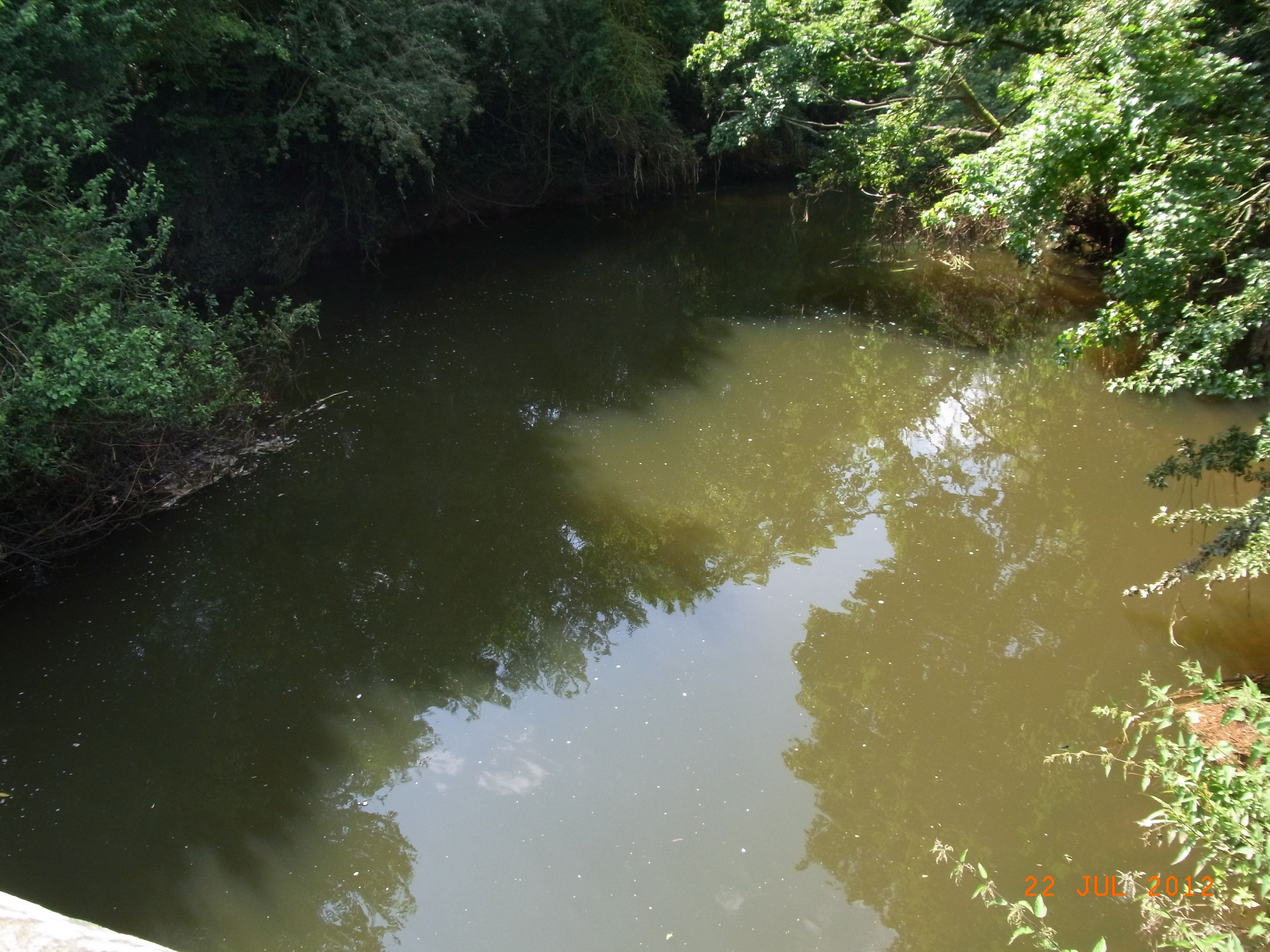
The river flows from Stones Bridge a little over one and a half kilometres
to the weir at Clifton Mill before going under the Mill Bridge on Lullington
Road.

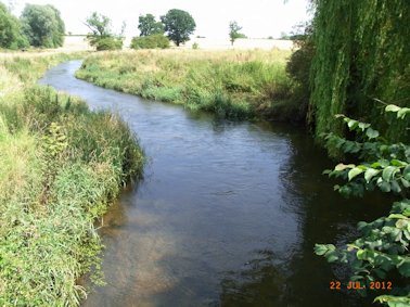
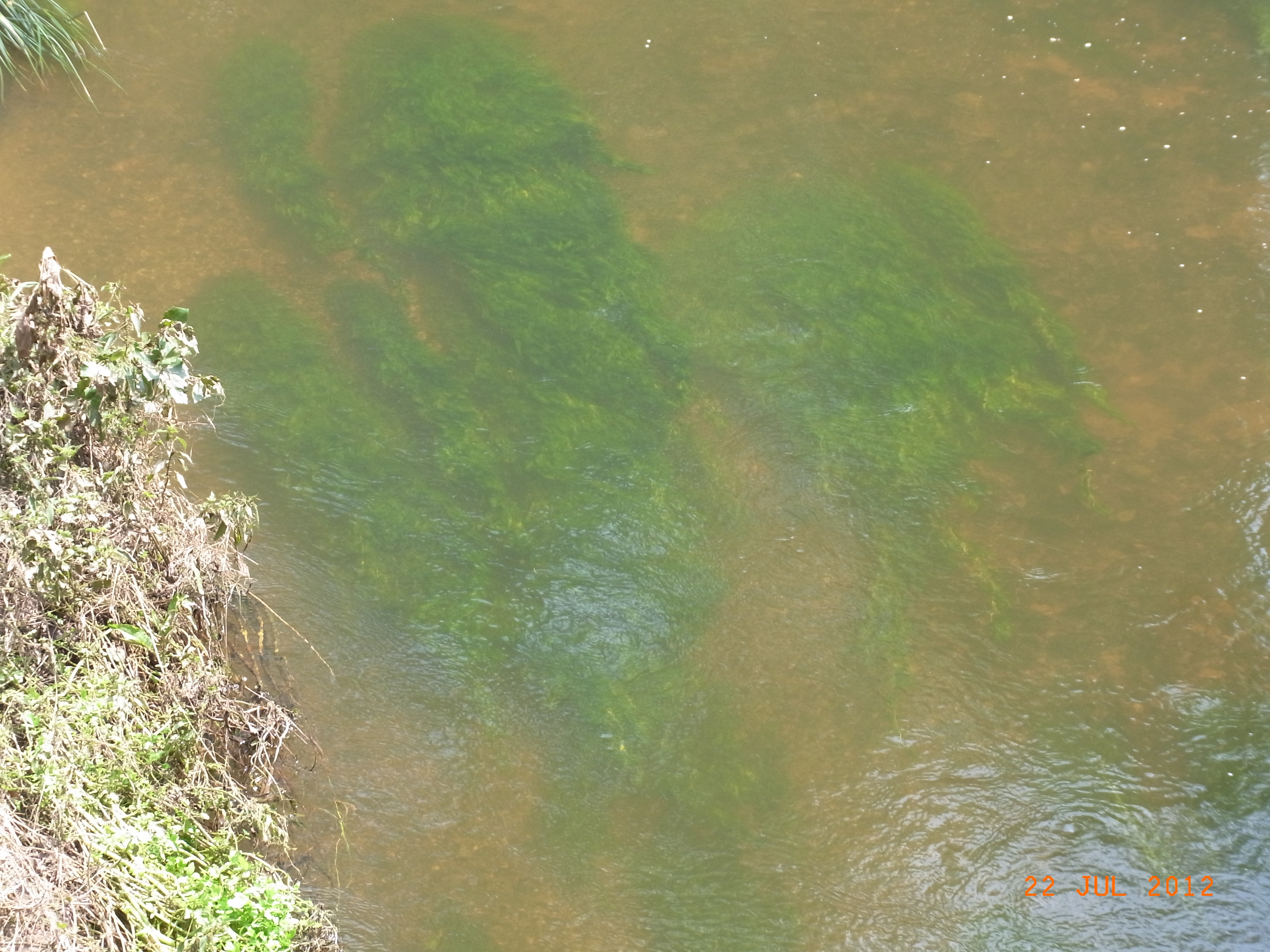
The river Mease looking west from Stones Bridge
As well as
being a SAC, the Mease is also a
Site of
Special Scientific Interest
(a 'Triple S I') under the UK's Wildlife and Countryside Act (1992).
For such a short river that is quite impressive. So what is it that has
earned the River Mease its European and UK status?
Well, it is a combination of the nature of the river itself – its citation
states that it is a 'relatively natural lowland river in agricultural land'.
This is quite unusual. Most lowland rivers run through industrial areas and
hence have often had the course of the channels changed and they have become
severely polluted. As it is so short, the Mease doesn't have much industry
and although its water quality is officially 'poor', work is being carried
out to help it recover.
In addition to the River itself, there are several species that make our
river special. Two species of fish – the Bullhead and the Spined Loach are
protected along with the White-Clawed Crayfish, the Otter and a plant called
River Crowfoot.
Wildlife In/around the River
When thinking of wildlife in rivers, most people probably think first of
fish. The Mease is a popular river with fishermen, having a good range of
fish species. The Environment Agency's annual fish survey at Stone's Bridge
shows that the number of fish has, however, declined in recent years. The
most numerous species is the Chub.
Perch and Roach are the next most common species, but Roach have
fallen from more than 100 being caught in the survey in 2003 to fewer than
twenty in 2011. Dace and Pike can also be found in the river. Gudgeon were
plentiful in former years – almost 80 were found in the 2007 survey but none
were found in 2011. This doesn't mean that there are no Gudgeon but is does
show that they are not as common as they once were. Bullhead and Spined
Loach are special species in the river and are covered below.
The fishing
rights for the stretch of the Mease between the two bridges are let to the
Burton Mutual Angling Club
http://www.burtonmutual.co.uk/
, so if you fancy enjoying a spot of fishing in the river, you can contact
them through the hyperlink.
There is also, of course, a good range of birds to be found around the
river. Kingfishers can be seen occasionally flitting up and down – flashes
of glorious iridescent blue on a sunny day are worth waiting for.
Herons enjoy fishing in the Mease and are regularly seen flying over the
village, probably from the heronry at Statfold. These large birds are mainly
grey with a 'crest' that flops down the back of the neck. They stand so
still when fishing that they are easy to miss – until they are startled and
take off in a great flap with a raucous croak.
Other more general species are seen by the river. Wood pigeon enjoy roosting
in the ivy in trees along the bank. Blue and Great Tits are happy in the
area as are many finches. Bullfinches have been seen further downstream and
may be present around the Clifton Campville stretch of the river. Larger
birds such as Rooks and Crows use neighbouring fields.
Amphibians are not generally 'river' animals and so are not found in the
Mease at Clifton Campville. They tend to prefer still water. Frogs, for
example prefer small shallow ponds while toads tend to go for larger areas
of water such as lakes.
Damselflies and Dragonflies can brighten up the river on summer days. Of the
more delicate damsels along the Clifton Campville stretch of the Mease we
get the Banded Demoiselle and its lovely cousin the Beautiful Demoiselle.
The female Beautiful Demoiselle is really stunning with its iridescent green
body glossy transparent brown wings. Its male is a dark metallic blue. The
Banded Demoiselle is identified by the large dark 'spots' on its wings that
appear to create a 'band'. The larger, more robust Dragonflies found by the
river include the Brown Hawker and the Common Hawker, although they need
ponds for breeding
One species that we don't have – but people often remember fondly, is the
Water Vole. These are 'Ratty' from Wind in the Willows. They are not rats
but are endearing furry relatives of the field vole that domestic cats
sometimes bring home. The Water Voles in the Mease have been lost in the
last twenty years probably because of mink. These are in the area and can
kill water voles. There is some hope that the return of Otters to the river
could lead to a reduction in the number of mink. This in turn could allow
the water vole to return – but only if the river is in good condition.
The plantlife
of the river is varied along the length of the river. A survey of the river
carried out by Scott Wilson in 2010 showed that the River Mease had
common
club-rush (Schoenoplectus lacustris), reed sweet-grass (Glyceria
maxima), reed canary-grass (Phalaris arundinacea), branched
bur-reed (Sparganium erectum), greater pond-sedge (Carex riparia)
and bulrush (Typha latifolia).
Submerged aquatic vegetation is more varied along the lower reaches of the
river and includes river crowfoot (Ranunculus fluitans), common
water-crowfoot (Ranunculus aquatilis), blunt- leaved pondweed (Potamogeton
obtusifolius), fennel pondweed (Potamogeton pectinatus),
arrowhead (Sagittaria sagittifolia) and yellow water-lily (Nuphar
lutea). This covered the whole of the Mease SAC and it would be
interesting to survey the plantlife just for the Clifton Campville stretch.
For more information on these species and for other wildlife around Clifton
Campville, see the natural history section of the website.
The Special Species
The River Mease has a number of species that are rare and in need of special
efforts to conserve them. These are:-
·
two species
of fish
·
the
Bullhead and
·
the Spined
Loach.
·
the White
Clawed Crayfish
·
the Otter
·
River
Crowfoot
In the middle of the last century (the 20th Century), the
Bullhead (Cottus gobio) was a common fish – found under stones by many a
short-trousered schoolboy hunting sticklebacks. When fully grown it is only
about 12 centimetres (five inches) long. Also known by some as 'Miller's
Thumb' it is a small and wonderfully camouflaged fish.
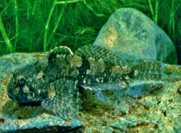
It is a quite sedentary fish staying still under its chosen stone waiting
for smaller fish to come within easy reach. Then the Bullhead darts out to
grab its meal. To avoid becoming a meal itself, the Bullhead has two spines
(one each side of its head) that deter larger fish from trying to eat it! It
has been described as an ugly fish. It is a dull brown colour with darker
mottling providing really effective camouflage. They breed in the spring
with the eggs being attached to stones and the male keeping guard until the
eggs hatch and the young swim away.
The Spined
Loach (Cobitis
taenia)
is a pretty
fish at about 10 centimetres (4 inches) long. It is protected in five river
systems in England but the population in the Mease is isolated from other
populations. As a result the Mease Spined Loach is genetically unique –
there is nowhere else in the world that has a Spined Loach like ours!
Spined Loaches are sometimes known as 'Weather fish' because when the
weather is about to become stormy, they tend to move from their favoured
home at the bottom of the river to splash about at the top. They are
slim-bodied fish, a little bit eel-like in shape. They are a pretty colour –
slightly yellow/orange underneath and speckled with dark scales on their
back. The 'spined' part of their name comes from spines that lie in grooves
from the side of their heads. They are related to the Stone Loach and both
species have six barbels (short spine-like projections) around their mouths.
These are used for sensing their surroundings and helping to catch prey as
they feed in the sandy bottom of the river

A few years ago, the idea that Otters (Lutra lutra) could be found
around Clifton Campville would have been ridiculed – and yet signs of otters
have been found on the Mease in this area. Indeed, a short while ago one was
spotted making its way downstream at Stones Bridge.
With their wonderfully cute faces and thick fur, Otters are one of Britain's
favourite species. As semi-aquatic mammals, Otters have large territories –
a male may have a territory up to 60 kilometres (40 miles) long, although
around 17 kilometres (11 miles) is more usual. So a male using the Mease
through Clifton, may extend his territory out into the Trent or Tame at
Croxall.
Males can grow up to 95 centimetres (37 inches) PLUS their tail which can be
up to 45 centimetres (18 inches) long. Females are shorter. Otters'
favourite food is fish although they will take other prey including crayfish
(see below!). They are mainly nocturnal and so their presence in the area is
generally known from tracks and other signs. Otter spraint (their
'droppings') is quite distinctive, smelling fishy or some say like new-mown
hay. The fish bones can usually be seen.

It is, however, the White-Clawed Crayfish
(Austropotamobius pallipes)
that is particularly special. It is widespread in most parts of England and
is common in parts of eastern Wales. A significant part of the EU resource
is found in the UK, but the species is now seriously threatened over most of
its range in Britain which is why we need to do what we can to protect it in
the Mease.
Looking like a mini lobster, the White-clawed Crayfish is an arthropod like
crabs and woodlice. They are an olive-brown colour, with pale-coloured
undersides to the claws (hence 'white-clawed'). It usually grows to only
about ten centimetres (four inches) long but it can grow to 12 centimetres
(5 inches) long. This nocturnal animal lives under rocks and stones in clean
water – often rivers but also lakes and ponds. It is a world-wide endangered
species.
Unfortunately
an alien crayfish from America – the 'Signal Crayfish' – has been introduced
and/or escaped in much of the UK and has caused the loss of many of the
native (White-clawed) Crayfish. It has done this partly because it carries a
disease that kills our crayfish but also it is bigger and more successful
when breeding. As a result, the White-Clawed Crayfish has only managed to
'hold-on' in a few areas of the country – and The River Mease is one such
area. Because it is so vulnerable, the protection of this species means that
it is illegal to interfere with it in anyway.
More information can be found at
http://www.environment-agency.gov.uk/homeandleisure/recreation/fishing/38055.aspx
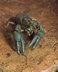
White-Clawed Crayfish
Finally it is important to remember that plants are a vital part of any
habitat. In the Mease, the River Crowfoot (Ranunculus fluitans)
is especially valuable as a submerged water plant.
River Crowfoot (Ranunculus fluitans)
The Future of the Mease
As a SAC and SSSI, the River Mease benefits from special attention from
Natural England and the Environment Agency which have recently launched a
Restoration Plan for the River Mease because although it is 'special' at the
moment, it won't be, unless it is cared for.
To enable them to identify the needs of the River, Natural England and the
Environment Agency, divide it into a number of 'reaches' – and four of these
fall within Clifton Campville (and Haunton). Each reach has been carefully
surveyed and categorised as either 'Rehabilitate', 'Restore' or 'Conserve
and enhance'.
The good news is that in Clifton Campville two of the reaches are good
enough to be classified as 'conserve and enhance' but along the north of
the village between the two bridges, the river is designated as being
'restore'. What does restoration mean? In summary it means trying to enable
the river to get back to the way it was before the former River Authorities
changed it in the 1970s and 80s.
In the past, the rivers authorities dredged rivers, cleared banks of
vegetation, straightened sections of rivers and created steep banks. They
generally created a 'sterile' environment. Unfortunately this was not
helpful to wildlife and in some ways caused problems for people. By allowing
rain water to flow quickly away from the fields and not be retained by
various plants and 'backwaters', the river authorities created the
conditions for floods downstream. Many of the recent flood problems in
places such as Tewkesbury and Yorkshire were the result of such actions. The
Mease had some work that has left it in need of help to return to its former
state.
The Plans for the River Mease at Clifton Campville
The main objectives for the River Mease in Clifton Campville, as assessed by
Natural England together with the Environment Agency, are
Along any river there are a few metres each side that occasionally become
flooded. The ideal is for these to have a variety of vegetation – trees,
shrubs, grasses and other herbaceous plants. These stretches are known as
the riparian zones. The 'conserve and enhance' sections in Clifton Campville
have reasonable riparian zones but some stretches in the 'restore' section
would benefit from a greater variety of vegetation.
Dredging in the past created deeper water with a muddy bottom which is not
what the Spined Loach, Bullhead and White-Clawed Crayfish need. They need
the gravelly, stony river bed that the Mease used to have.
The most significant 'blockage' on the Mease is the weir at Clifton
Campville. It causes a number of problems or potential problems. For the
fish, crayfish and other animals, it prevents them from moving up and down
the river. This means that they become restricted to shorter stretches of
the river and are not able to take advantage of the full length of the river
for breeding and living in.

At times of heavy rain, the weir causes water to 'back up', flooding the
banks further upstream. This causes problems for farmers by reducing crop
yields when the floods occur at the 'wrong' time of the year. It also means
that the 'once in a hundred years' floods' are predicted to flood houses in
the village. For these reasons, the Restoration Plan includes removing the
Clifton Campville weir (along with other weirs in other areas such as
Packington) to reduce these problems.
The term 'woody debris' is not one we use everyday, but it refers to all
sorts of bits of trees that come downstream – everything from tree trunks to
tiny twigs. They are an essential part of healthy rivers but were removed by
the former River Authorities. Staffordshire Wildlife Trust produced a
booklet called 'Fish Live in Trees Too' by Nick Mott, their Senior Wetlands
Officer. In it he explains how fish need the quiet places and sheltered
areas that are created by fallen branches and other 'woody debris'. To help
the fish and invertebrates in the Mease, the Restoration Plan includes
increasing the amount of 'woody debris' in the Mease.
Any work to restore the River Mease – Clifton Campville or anywhere else, is
organised and funded by Natural England and/or the Environment Agency, but
can only happen with the co-operation of individual landowners.
It would change the nature of the river – creating 'riffles' (shallow
gravelly stretches) or making the river appear narrower as vegetation
reverts to its natural state. The important thing to remember, however, is
that it would be the river returning to the way it was – and arguably should
be – before the old River Authorities 'attacked' it fifty years ago.
Nothing will happen soon. It all takes time but it will be interesting to
watch the river become itself again.
The nice thing is that of any funding allocated to Natural England, the
River Mease gets 'first call' because of its SAC status. So there is
potential for Clifton Campville to benefit from taxpayers' money when any of
the restoration work is carried out.
This European designation is intended to establish protection for specific
habitats rather than for individual species. However it is often the
presence of particular species that exist in particular habitats that result
in an area being recognised as 'significant at the European level'.
Special Areas of Conservation (SACs) are strictly protected sites designated
under the EC Habitats Directive. Article 3 of the Habitats Directive
requires the establishment of a European network of important high-quality
conservation sites that will make a significant contribution to conserving
the 189 habitat types and 788 species identified in Annexes I and II of the
Directive. The listed habitat types and species are those considered to be
most in need of conservation at a European level.
In the case of the Mease, there are several species that have added to the
value of the habitat, but the river is being recognised as being unusual in
that it is 'a relatively natural lowland river in an area of intense
agriculture'.
Because of its shortness, there is relatively little industry to pollute the
river. The two main causes of poor water quality are the output from sewage
works and the 'run-off' of agricultural chemicals. Natural England and the
Environment Agency are carrying out research to assess the extent of any
pollution coming from the A42.
There are eleven sewage treatment works in the Mease catchment area,
including our own in Netherseal Lane. Severn Trent are carrying out trials
to further reduce the phosphate levels in the water discharged into the
river.
The other key threat to the Mease is water extraction. Farmers wanting to
extract water from the river can do so only with the express permission of
the Environment Agency. They have strict regulations controlling when (and
how much) water can be extracted.
In Clifton Campville some farmers have permission to extract water from the
Mease but only when water levels are at a reasonable level. When the levels
fall, the Environment Agency issues landowners with letters which
temporarily remove permission to extract water.
Site of
Special Scientific Interest
The designation SSSI (“triple S I”) is a UK one and comes before an area can
be considered for being granted European conservation status (SAC).
Natural England is the body responsible for identifying Sites of Special
Scientific Interest and protecting the SSSIs in England under the Wildlife
and Countryside Act 1981 (as amended by the Countryside and Rights of Way
Act 2000). They notify
landowners of their responsibilities when an area is awarded SSSI status and
work with them to ensure that the areas are properly protected for future
generations.
Interestingly, most people think of these as 'wildlife' protection areas and
that is true – but they also apply to sites of Geological significance. For
the Mease, however, it is the wildlife that has earned it its SSSI status.
However it does provide clear legal protection which must be taken into
account by landowners as they manage their land and by Local Authorities
when considering planning applications.
The first SSSIs were identified in 1949 when the then Nature Conservancy
notified local authorities of SSSIs, so their conservation interest could be
taken into account during the planning process. As people have begun to
realise that the health of the natural world has an impact on the health of
the human world, more attention has been paid to ensuring that the
'biodiversity' – or range of species – is maintained for future generations
of humans to enjoy.
Natural
England produces a 'List' for each SSSI detailing operations that require
their consent before landowners can carry out specific actions. The 'List'
for the Mease can be seen via
http://www.sssi.naturalengland.org.uk/Special/sssi/sssi_details.cfm?sssi_id=2000416
. Some people think that this means that the landowners are prevented from
doing things, but in practice Natural England and the Environment Agency are
keen to give the 'OK' when asked. It is really just a means of ensuring that
no harm is done to this valuable River.
Although fishing is allowed, catching – or even “ Injuring, killing or
removing any wild animal and damaging, disturbing or obstructing their eggs,
nests and places of shelter” is not permitted for several species –
including the Spined Loach and Bullhead (the reasons for the SSSI/SAC) but
also minnows, three-spined sticklebacks and the Stone Loach. These are
included for several reasons. Partly because of their similarity (especially
their size) to the Bullhead and the Spined Loach, protecting the minnow and
stickleback ensures that the Bullhead and Spined Loach aren't mistaken for
minnows or sticklebacks. Also, however, the SAC is designed to protect a
whole area of habitat – and that includes species that form a significant
part of the food chain – such a minnows and three-spined sticklebacks. There
is no point in protecting the Otter and getting it back in Clifton – if
there is no food for it to eat!